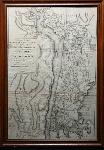
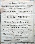
A Plan of the Operations of the King’s Army under the Command of Gen. Sr. William Howe, K.B. in New York and East New Jersey Against the American Forces Commanded by General Washington, From the 12th of October to the 28th of November 1776. Wherein is Particularly Distinguished the Engagement of the White Plains the 28th of October. Engraved for Stedman’s History of the American War. [London: For the Author], 1793.
720 x 490 mm. in frame. Some light offsetting from where originally folded, minor repaired tear at left edge, otherwise a very good and tastefully framed and glazed copy.
A handsome and important copper engraved map depicting the battle which took place at White Plains on October 28th, 1776, best known as Sir William Howe’s missed opportunity to rout General George Washington’s forces. This map, which was first done in 1777 by Claude-Joseph Sauthier, was re-issued to illustrate Stedman’s History of the American War.
Howe (1729-1814) was a British General during the American Revolution. After leading the British troops at the Battle of Bunker Hill, he was made Commander-in Chief of the troops in America. He fought General George Washington a number of times, most notably at the Battle of Long Island, where Howe was victorious. While Washington abandoned the field during the battle of White Plains, which most consider to be inconclusive, it seems that Howe failed to press his advantage against Washington, which may be what cost the British the War. During the following year, his campaigns met with much criticism, causing him to request relief from his command.
Stedman (1753-1812) was a military historian, and son of a British Supreme Court Judge in Philadelphia. Like his father, he remained loyal to the British Crown and at the outbreak of war, he was made Commissary to the troops under the Command of Howe. At the end of the War, he returned to England where he began work on his History of the Origin, Progress and Termination of the American War (1794) which met with much acclaim and was considered the authoritative work on the subject for the next century.
Sauthier (1736-1802) was an Alsacian cartographer and surveyor noted for his skill in architecture and illustration. He was employed by the British Army during the American War of the Revolution, for whom he made a number of important maps of the New York and New Jersey regions.
Phillips, A List of Maps of North America in the Library of Congress, p. 485; In: Sabin, 91057
ID:
3082
$
1,800

