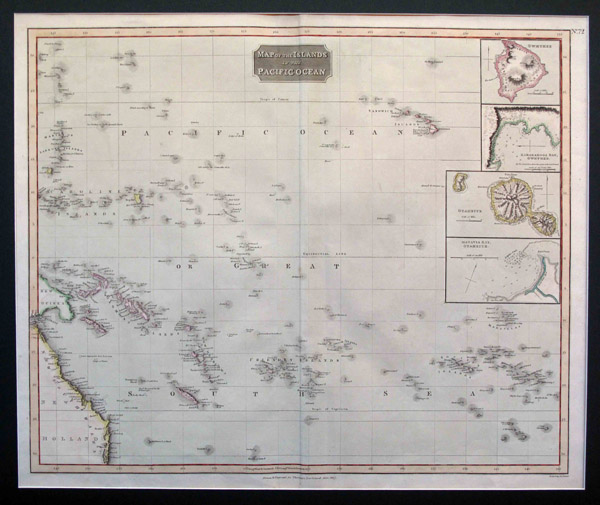
Map of the Islands in the Pacific Ocean. [Edinburgh: Printed by George Ramsay and Co. for John Thomson and Co.], 1817.
Engraved map with four insets. (625 x 515 mm. to platemark, 725 x 535 mm. with margins) Centerfold, some faint offsetting from insets, otherwise a bright, beautiful copy with contemporary hand-colouring.
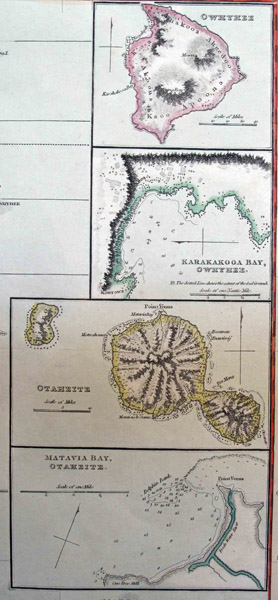
Fine large map of the islands of the Pacific with four insets of Owhyhee, Karakakooa Bay, Otaheite, and Matavia Bay, number 72 in John Thomson's New General Atlas. Included are the Sandwich Islands, the Caroline Islands (now part of Micronesia), the Friendly Islands (Tonga), the Society Islands (French Polynesia inc. Tahiti, Moorea, Bora Bora, Huahine, et al.), the Marquesas (French Polynesia), New Caledonia, the Solomon Islands and the New Hebrides (the colonial name for Vanuatu) as well as part of New Guinea and New Holland (the New South Wales portion of Australia).
Many of the colonial names for the islands evoke images of swashbuckling and pirates, such as "Disappointment Island", ""Savage Island", Dangerous Archipelago", "Island of Danger" and "Rock Like a Ship", while several others are of a more religious theme "Conversion of St. Paul", "St. Elmo" and "St. Jaun Baptista." Of special interest are the accompanying notes, which include dates of discovery, the date and location of the Death of Captain Cook, as well as indications of several islands of dubious existence. Truly a fascinating item.
ID:
5137
$
500